Published-release documentation · release compatibility
Position Encodings
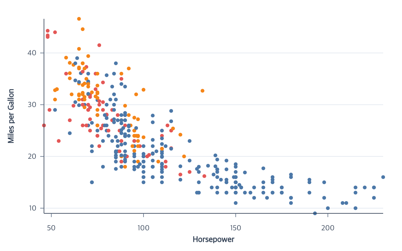
Choose the position family from the semantic mark and field relationship. All position actions infer the current mark, use or create a compatible coordinate, resolve a channel scale, and explicitly materialize the affected graphics.
Supported marks and modes
| Action | Supported marks | Field types | Important modes |
|---|---|---|---|
encodeX |
point, line, area, bar, rect, rule, tick, text | point/line/area/bar/rect/rule/tick/text: quantitative, temporal, ordinal, nominal | field; rule, area, rect, and independent text also accept datum; bar accepts aggregate or bin |
encodeY |
point, line, area, bar, rect, rule, tick, text | point/line/area/bar/rect/rule/tick/text: quantitative, temporal, ordinal, nominal | field; rule, area, rect, and independent text also accept datum; bar accepts aggregate or count |
encodeX2 / encodeY2 |
area, ranged bar, rect, rule | area/ranged bar/rect/rule: matching primary | secondary field; rule, area, and rect also accept datum |
encodeTheta |
point, line, arc | point/line: quantitative, temporal, ordinal, nominal; arc: quantitative, ordinal, nominal | arc maps direct quantitative values, category counts, or category-weighted sums to proportional sectors |
encodeR |
point, line, arc | point/line/arc: quantitative | radial position; arc combines it with a categorical theta band |
encodeParallelCoordinates |
line | line: quantitative, ordinal | atomic ordered dimensions; one namespaced scale and axis per dimension |
encodeDx / encodeDy |
text | text: quantitative | independent Text only; finite field or constant logical-pixel offsets, no scale or guide; field offsets establish row grain |
Choose an encoding
| Goal | Required state | Actions | Detailed page |
|---|---|---|---|
| Position points | point mark, quantitative, temporal, or ordinal fields | encodeX, encodeY |
Quantitative positions |
| Position Polar points | point mark, angle field and quantitative radius field | encodeTheta, encodeR |
Polar point tutorial |
| Draw Polar lines or radar paths | line mark, angle field and quantitative radius field | encodeTheta, encodeR |
Polar line tutorial |
| Draw pies, donuts, rose charts, or radial bars | arc mark, direct quantitative theta, categorical count/weighted-sum theta, or quantitative radius | encodeTheta, optional encodeR |
Polar arc tutorial |
| Draw cells or interval shading | rect mark, band positions, paired endpoints, or one plot-spanning interval | encodeX, encodeY, optional encodeX2, encodeY2 |
Rect marks |
| Draw an aggregate time series | line mark, temporal x and quantitative y | encodeX, encodeY |
Temporal lines |
| Build vertical aggregate bars | bar mark, ordinal/temporal x and quantitative y | encodeX, encodeY |
Bar positions |
| Build horizontal aggregate bars | bar mark, quantitative x and ordinal/temporal y | encodeX, encodeY |
Bar positions |
| Order categorical positions | nominal/ordinal x, y, or theta | orderCategories, removeCategoryOrder |
Category ordering |
| Bin and count values | bar mark, quantitative field | encodeHistogram or encodeX + encodeY |
Histograms |
| Estimate a distribution | area mark, quantitative field | encodeDensity |
Encodings |
| Center aligned area series | area mark, quantitative/temporal x, non-negative quantitative y, nominal group | encodeY({ stack: "center" }) or encodeColor({ layout: "center" }) |
Color encoding |
| Draw full-span or bounded rules | rule mark, field or datum endpoints | encodeX, encodeY, encodeX2, encodeY2 |
Rule endpoints |
| Control within-category grouping | categorical bar, point, or rule position | encodeXOffset, encodeYOffset |
Offsets |
For ordinary grouped bar charts, prefer
encodeColor({ field, layout: "group" }); it calls the matching advanced
directional offset action for the same field.
For a center-stacked area, each group must have exactly one non-negative value
at every x position. encodeY({ stack: "center" }) preserves the original y
field and creates concrete lower/upper area boundaries around zero. The
equivalent encodeColor({ layout: "center" }) also creates the matching nominal
group when it is absent. Center stacking is not supported for bars, ranged
areas, signed values, duplicate group/x rows, or missing positions.
Shared inference
targetdefaults to the current compatible mark.coordinateuses the layer coordinate, then the documentedmainCartesian orpolarPolar default for the requested channel family.- Scale IDs default to their channel names:
x,y,theta,radius,xOffset, andyOffset. - Automatic continuous y ranges run bottom-to-top. Discrete y positions run top-to-bottom so horizontal categories follow domain order.
- Temporal values accept finite timestamps, four-digit numeric/string years, and valid date strings. Four-digit values are interpreted as UTC years.
- Ambiguous resources produce an error instead of an arbitrary selection.
Polar positions
Contextual fragment. Use an ES module with the imports, data, and prepared resource state described in this section. Resolve these names from setup in this fragment or section; alternatives branch from the same base.
program
  .encodeTheta({ field: "angle" })
  .encodeR({ field: "distance" })
  .encodePointRadius({ value: 3 });
encodeTheta accepts point or line marks with quantitative, temporal, ordinal,
or nominal fields. For an arc mark, an aggregate-free quantitative field makes
one proportional sector per positive source row. aggregate: "count" over a
nominal or ordinal field creates count-proportional sectors. aggregate: "sum"
plus a non-negative finite weight field creates category-weighted
proportional sectors. Categorical theta plus quantitative encodeR creates
radial sectors; direct quantitative arc theta does not combine with encodeR.
Quantitative angle scales are linear; temporal angles use time scales; discrete
angles use point or band scales. The automatic range is [0, 360] degrees with
0 at 12 o’clock and clockwise positive direction.
encodeR accepts a quantitative field and linear, log, pow, sqrt, or symlog
scale policies. Its automatic range fits the smaller plot dimension. Explicit
ranges are non-negative logical pixels and must fit the current plot bounds.
The two actions are order-independent. One Polar channel may exist as an
incomplete semantic assignment, but points or paths become visible only after
both channels and their scales resolve. A line may use
createLineMark({ closed: true }) for a closed radar path. Cartesian x/y and
Polar theta/radius cannot be mixed on one layer.
Measured radial sectors
On an Arc mark with categorical theta, encodeR can aggregate a measure per
category and encode either annular area or radial length. This fragment assumes
program already has data with category and non-negative numeric value fields:
Contextual fragment. Use an ES module with the imports, data, and prepared resource state described in this section. Resolve these names from setup in this fragment or section; alternatives branch from the same base.
program
  .createArcMark({ innerRadius: 0.5 })
  .encodeTheta({ field: "category", fieldType: "nominal" })
  .encodeR({ field: "value", aggregate: "sum", mapping: "area" })
  .createRadialAxis();
Use mapping: "radius-length" to make length from the inner edge proportional
to the aggregate. Use { aggregate: "count", mapping: "area" } without a field
to count rows per category. Both modes use equal-angle sectors and a zero-based
linear scale. Zero categories remain in categorical domains but draw no sector.
Negative, nonfinite, all-zero, and unrepresentable positive-thickness inputs are errors.
The radial axis shows count or sum units with the same mapping as the sectors.
An explicit radius range [inner, outer] defines the hole and must agree with
an explicitly specified Arc innerRadius (ratio or fixed pixels). These modes require zero theta
padding and padAngle: 0; nice: true, zero: false, and reverse: true are errors.
Reassigning encodeR preserves omitted mapping and aggregate. To change the
mapping on a shared measured scale, use editScale({ id, radialMapping: "area" });
all its compatible sectors and radial guides update together. Ordinary point
radius and measured Arc radius require separate scales.
Use encodeR({ field: "value", mapping: false }) to refine a measured Arc into
ordinary row-level radial length. This one action removes the inherited
count/sum aggregate, clears the scale’s measured mapping, and updates existing
radial guides. It preserves the mark, data, categorical theta order, and
compatible styling. This is an explicit semantic change: mapping: "area"
makes aggregate annular area proportional to value, while mapping: false
makes each row’s radius proportional to its value. A measured scale shared by
another aggregate Arc must be separated before this transition.
Rule endpoints
Rule positions use the same encodeX and encodeY actions and accept exactly
one of field or datum. Datum-only rules infer finite numbers as quantitative
and other supported scalar values as nominal. Field rules, temporal data, and
ambiguous values require an explicit fieldType:
Contextual fragment. Use an ES module with the imports, data, and prepared resource state described in this section. Resolve these names from setup in this fragment or section; alternatives branch from the same base.
program
  .createRuleMark()
  .encodeX({ datum: 15 })
  .encodeY({ datum: 20 })
  .encodeY2({ datum: 80, fieldType: "quantitative" });
encodeX2 and rule encodeY2 require their corresponding primary endpoint
and share its scale, coordinate, and field type. x alone draws a vertical
full-span rule; y alone draws a horizontal full-span rule. x+y+y2 and
y+x+x2 draw bounded intervals, while all four endpoints draw a diagonal.
Calling the same action again replaces only that endpoint.
Quantitative ranges
Full encodeXRange and encodeYRange accept field names or finite
{ datum: number } bounds for Rect and Rule marks. Either or both bounds may
be constants; the two endpoints share one scale and coordinate. No source rows
or columns are added. The wrapper validates the final pair before changing it
and records the ordinary primary/secondary encoding actions.
Bar ranges require two fields. Temporal ranges also require two fields; use the individual position encoders for temporal constants. Area bounds retain the more specific requirements below.
Area bounds
Area encodeXRange and encodeYRange accept a field name or { datum: number }
for each bound, with at least one field. Bounds retain their order even when they cross.
The two endpoints share one scale; reassignment validates the final pair and scale together.
encodeX2 and encodeY2 accept quantitative datum bounds without an explicit fieldType.
Use a finite, nonzero baseline for log scales.
Related
Encodings · Scale options · Coordinates · Series encodings
Documentation provenance
293 actions · sha256:e755591a2e5f5e2b494867583876e28020a478c5220b77bdc6ad469a6224891d